After getting my Snow Canyon “fix” (along with a big plate of turkey for Thanksgiving dinner,) I departed St. George, UT bound for Page, AZ to get closer to the location for the Wave hike, and to explore a few of the attractions near Lake Powell. I didn’t want to cut through Zion National Park, because I knew it would only frustrate me to drive right through one of my favorite parks without time to stop and explore. Having been here over Thanksgiving six years ago, I wanted to explore some different areas of Southern Utah this time. However, I was afraid bypassing the park would also mean bypassing the scenery. Thankfully, my worries were unfounded, as the drive revealed one beautiful scene after another.
While soaking my aching muscles in the Green Valley Spa hot tub after my eight mile hike, I met a family from northern Utah. Through recounting our respective Thanksgiving day events, I learned about a local favorite hiking destination nearby, “Red Cliffs Recreational Area,” just 14 miles north of St George, and only one exit out of my way en route to Page, AZ.

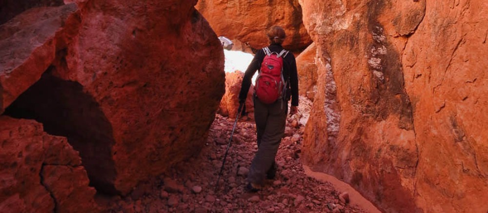
Red Reef Trail
Although the recreational area had several hiking trails, the Red Reef Trail was highly recommended because it follows the Quail Creek to a small waterfall — a rare find in the desert.

I followed the pretty little tree-lined creek for about two miles beyond the waterfall, fording the creek across stepping stones, scrambling over and under red sandstone boulders (including sliding down one, butt and camera display screen first! GROAN!!!)
 I knew there was something interesting up ahead, as I could hear the yipping and yahooing down the canyon, so I wanted to see what all the excitement was about. Around the bend, I came upon a group of rock climbers…
But I made a U-turn when it came to this….
The recreational area contains a tiny little campground with only eleven sites and two vault toilets, available to only the tiniest of campers….
Because you must navigate not one, but two of these to get there!
 Shortly after passing through Hurricane, UT, the road began to ascend, and my ears started popping. Just as I left the outskirts of Zion with all it’s majesty in the distance, I came upon the Grand Staircase-Escalante, 1.9 million acres of the largest land area of all U.S. National Monuments. There was something so mysterious about this stretch of land, with the sun setting low in the southwestern sky, casting long deep shadows in the multicolored cliffs and columns of sandstone. Knowing that the well disguised Wave hike was just beyond the Vermillion cliffs without so much as a trail marker added to the intrigue, while names like “Peekaboo” and “Spooky Canyon” almost lent a sense of foreboding.
The monument is administered by the Bureau of Land Management rather than the typical National Park Service, and their BLM presence, the RV boondocker’s “Mecca,” is prevalent along this road. There were large information centers in both St. George as well as Kanab. Notice the nice long pull-through parking spaces!

BLM, Boondocker’s “Mecca”
 Just about the time the Grand Staircase started to flatten out, I approached the town of Big Water where I saw the beginnings of Lake Powell, followed by signs for the Glen Canyon Dam. I arrived just in time to walk across the dam just as dusk was falling.

Glen Canyon Dam, built 1963

Colorado River exits Glen Canyon Dam
The Page restaurant I had chosen for dinner from TripAdvisor reviews was closed for the season. The next place on my list had a 40 minute wait. Tired from all the driving, I decided to fall back on my old standby, KFC, only to find it an abandoned shell of a building. Finally, I resorted to McDonalds as a last resort to try one of their new “CBO” burgers (cheddar, bacon, and onion) only to get back to my hotel and discover they had given me the wrong order. Such an anti-climactic end to an otherwise spectacular day!